1964: Alaska's Good Friday Earthquake
- ALAN TAYLOR
- MAY 30, 2014
- 36 PHOTOS
- IN FOCUS
On March 27, 1964, a megathrust earthquake struck Alaska, about 15 miles below Prince William Sound, halfway between Anchorage and Valdez. The quake had a moment magnitude of 9.2, making it the second most powerful earthquake ever recorded. The initial quake and subsequent underwater landslides caused numerous tsunamis, which inflicted heavy damage on the coastal towns of Valdez, Whittier, Seward, and Kodiak. Alaska's biggest city, Anchorage, suffered numerous landslides, destroying city blocks and neighborhoods. An estimated 139 people were killed, most by tsunamis -- including 16 deaths on Oregon and California shorelines. The old town site of Valdez was abandoned, with reconstruction taking place on stable ground nearby. This is the fourth of five entries focusing on events of the year 1964 this week (and next Monday). Monday's entry will feature images of the New York World's Fair.
 Read moreThe rails in this approach to a railroad bridge near the head of Turnagain Arm, southeast of Anchorage, were torn from their ties and buckled laterally by movement of the riverbanks during a massive earthquake on March 27, 1964. The bridge was also compressed and developed a hump from vertical buckling. #U.S. Geological Survey
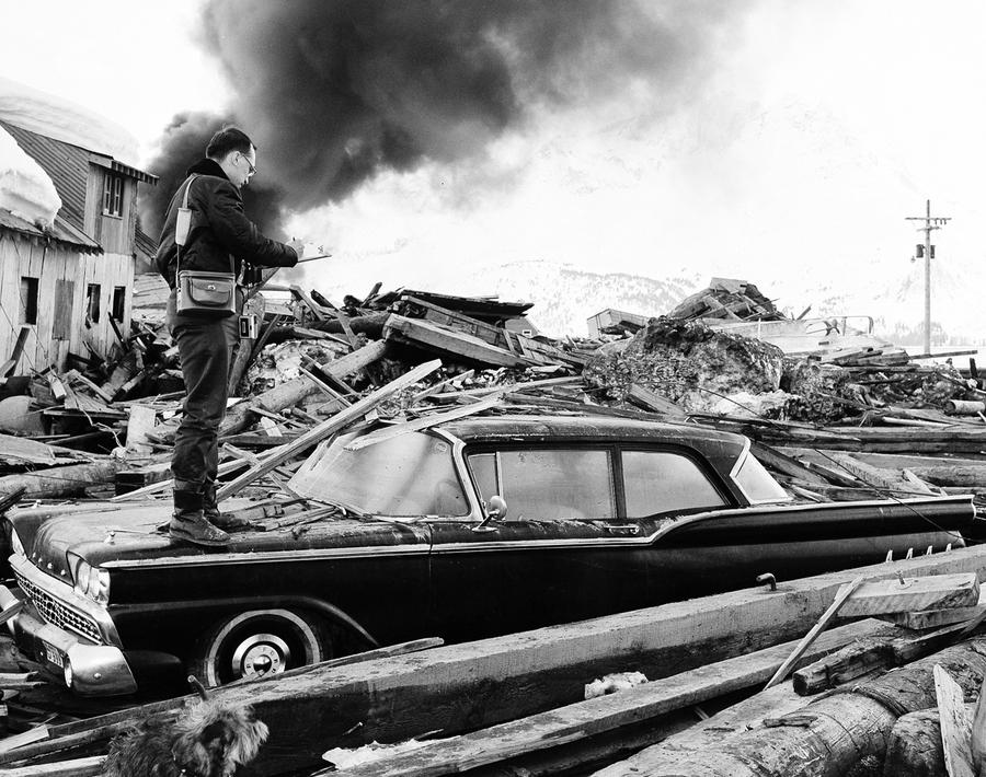
![]() Read moreA photographer looks over wreckage as smoke rises in the background from burning oil storage tanks in Valdez, Alaska, on March 29, 1964, two days after the earthquake struck. #AP Photo
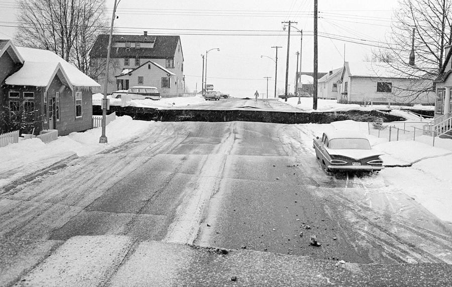
Read moreA photographer looks over wreckage as smoke rises in the background from burning oil storage tanks in Valdez, Alaska, on March 29, 1964, two days after the earthquake struck. #AP Photo![]() Read moreDowntown Anchorage, the collapse of Fourth Avenue near C Street, due to a landslide caused by the earthquake. Before the shock, the sidewalk on the left was at street level with the one on the right. #U.S. Army
Read moreDowntown Anchorage, the collapse of Fourth Avenue near C Street, due to a landslide caused by the earthquake. Before the shock, the sidewalk on the left was at street level with the one on the right. #U.S. Army![]() Read moreThe dock area, a tank farm, and railroad facilities in Whittier, Alaska were severely damaged by surge-waves developed by underwater landslides in Passage Canal, on March 27, 1964. The waves inundated the area of darkened ground, where the snow was soiled or removed by the waves. #U.S. Geological Survey
Read moreThe dock area, a tank farm, and railroad facilities in Whittier, Alaska were severely damaged by surge-waves developed by underwater landslides in Passage Canal, on March 27, 1964. The waves inundated the area of darkened ground, where the snow was soiled or removed by the waves. #U.S. Geological Survey![]() Read moreThe waterfront of Seward, Alaska, weeks after the earthquake, looking north. Note the "scalloped" shoreline left by the underwater landslides, the severed tracks in the railroad yard which dangle over the landslide scarp, and the wind row-like heaps of railroad cars and other debris thrown up by the tsunami waves. #U.S. Geological Survey
Read moreThe waterfront of Seward, Alaska, weeks after the earthquake, looking north. Note the "scalloped" shoreline left by the underwater landslides, the severed tracks in the railroad yard which dangle over the landslide scarp, and the wind row-like heaps of railroad cars and other debris thrown up by the tsunami waves. #U.S. Geological Survey![]() AP Photo
AP Photo![]() Read moreThe Four Seasons Apartments in Anchorage was a six-story lift-slab reinforced concrete building which collapsed during the earthquake. The building was under construction, but structurally completed, at the time of the quake. #U.S. Geological Survey
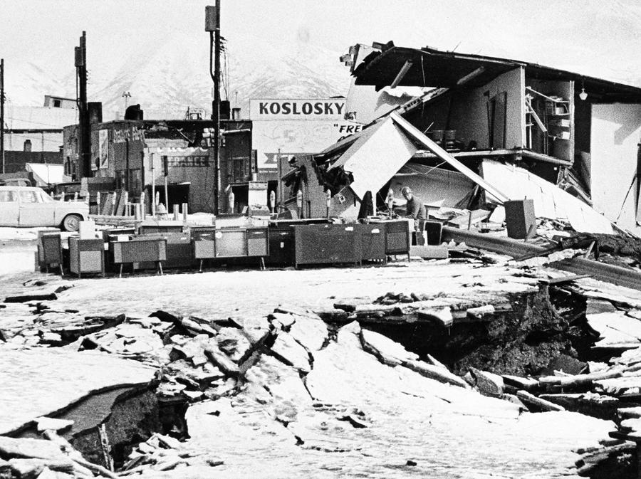
Read moreThe Four Seasons Apartments in Anchorage was a six-story lift-slab reinforced concrete building which collapsed during the earthquake. The building was under construction, but structurally completed, at the time of the quake. #U.S. Geological Survey![]() Read moreAn unidentified man sits at a desk beside hi-fi sets moved to the middle of Fourth Avenue in Anchorage on March 31, 1964. The items were moved from a store that was demolished in the earthquake. #AP Photo
Read moreAn unidentified man sits at a desk beside hi-fi sets moved to the middle of Fourth Avenue in Anchorage on March 31, 1964. The items were moved from a store that was demolished in the earthquake. #AP Photo![]() The marquee of the Denali Theater sits even with the street in Anchorage. The building's foundation subsided until the marquee came to rest on the sidewalk. #U.S. Geological Survey
The marquee of the Denali Theater sits even with the street in Anchorage. The building's foundation subsided until the marquee came to rest on the sidewalk. #U.S. Geological Survey![]() Read moreThe path of destruction made by the quake in Alaska followed by a tsunami can be seen in this aerial view of Kodiak on March 29, 1964. The wave swept in from the lower left and towards upper right, pushing and smashing everything in its way. #AP Photo
Read moreThe path of destruction made by the quake in Alaska followed by a tsunami can be seen in this aerial view of Kodiak on March 29, 1964. The wave swept in from the lower left and towards upper right, pushing and smashing everything in its way. #AP Photo![]() Read moreChaotic condition of the commercial section of Kodiak following inundation by seismic sea waves. The small boat harbor contained an estimated 160 crab and salmon fishing boats when the waves struck. #U.S. Navy/NOAA
Read moreChaotic condition of the commercial section of Kodiak following inundation by seismic sea waves. The small boat harbor contained an estimated 160 crab and salmon fishing boats when the waves struck. #U.S. Navy/NOAA![]() Read moreA view of the destruction of Valdez, Alaska. Thirty-one residents died during the earthquake and subsequent tsunami. Instability and vulnerability to future tsunamis made the old town site too dangerous to rebuild, so the town was relocated several miles west to more stable ground, and rebuilt. #NOAA
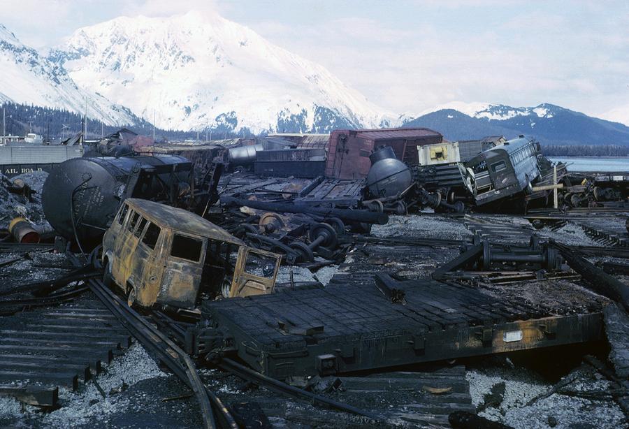
Read moreA view of the destruction of Valdez, Alaska. Thirty-one residents died during the earthquake and subsequent tsunami. Instability and vulnerability to future tsunamis made the old town site too dangerous to rebuild, so the town was relocated several miles west to more stable ground, and rebuilt. #NOAA![]() Chaos on the waterfront in Seward, burned-out vehicles and rail cars strewn across the ruined rail yard. #NOAA
Chaos on the waterfront in Seward, burned-out vehicles and rail cars strewn across the ruined rail yard. #NOAA![]() A mother stands watch as her child plays in a puddle of water near her earthquake-shattered home in Kodiak, Alaska in March of 1964. #AP Photo/File
A mother stands watch as her child plays in a puddle of water near her earthquake-shattered home in Kodiak, Alaska in March of 1964. #AP Photo/File![]() Read moreTsunami damage and high-water line at Seward. The tsunami waves washed the snow from the lower slopes of the hillsides, and the height of the highest wave is marked by the sharp "snow line" on the hillside behind and just above the rooftop at left center. #U.S. Geological Survey
Read moreTsunami damage and high-water line at Seward. The tsunami waves washed the snow from the lower slopes of the hillsides, and the height of the highest wave is marked by the sharp "snow line" on the hillside behind and just above the rooftop at left center. #U.S. Geological Survey![]() NOAA
NOAA![]() Read moreSupport columns punched through the deck of the Twentymile River Bridge, as it collapsed during the earthquake, near Turnagain Arm on Cook Inlet. The adjacent steel railroad bridge survived with only minor damage. #U.S. Geological Survey
Read moreSupport columns punched through the deck of the Twentymile River Bridge, as it collapsed during the earthquake, near Turnagain Arm on Cook Inlet. The adjacent steel railroad bridge survived with only minor damage. #U.S. Geological Survey![]() U.S. Geological Survey
U.S. Geological Survey![]() In an Anchorage neighborhood, a wooden fence at the toe of the L Street landslide, buckled and shortened by compression. #U.S. Geological Survey
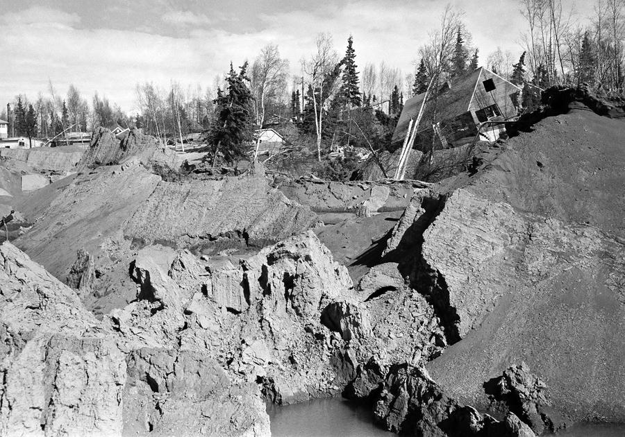
In an Anchorage neighborhood, a wooden fence at the toe of the L Street landslide, buckled and shortened by compression. #U.S. Geological Survey![]() An Anchorage neighborhood name Turnagain Heights was partially destroyed by a landslide shortly after the earthquake. #W.R. Hansen/U.S. Geological Survey
An Anchorage neighborhood name Turnagain Heights was partially destroyed by a landslide shortly after the earthquake. #W.R. Hansen/U.S. Geological Survey![]() NOAA
NOAA![]() Damaged homes in the Turnagain Heights landslide area in Anchorage.#U.S. Geological Survey
Damaged homes in the Turnagain Heights landslide area in Anchorage.#U.S. Geological Survey![]() Read moreA wider aerial view of the Turnagain Heights landslide. Most of this area is now a park - you can see it today on Google Maps. #A. Grantz/U.S. Geological Survey
Read moreA wider aerial view of the Turnagain Heights landslide. Most of this area is now a park - you can see it today on Google Maps. #A. Grantz/U.S. Geological Survey![]() AP Photo
AP Photo![]() Read moreThis highway embankment fissured and spread, cracking down the middle. The road was built on thick deposits of alluvium and tidal estuary mud along Turnagain Arm near Portage. #U.S. Geological Survey
Read moreThis highway embankment fissured and spread, cracking down the middle. The road was built on thick deposits of alluvium and tidal estuary mud along Turnagain Arm near Portage. #U.S. Geological Survey![]() The village of Portage, at the head of Turnagain Arm, flooded at high tide as a result of 6 feet of tectonic subsidence during the earthquake. #U.S. Geological Survey
The village of Portage, at the head of Turnagain Arm, flooded at high tide as a result of 6 feet of tectonic subsidence during the earthquake. #U.S. Geological Survey![]() Read moreWith the city under martial law, soldiers patrol a downtown street in Anchorage, Alaska, on March 28, 1964. In background is the wreckage of the five-story J.C. Penney's store at Fifth Avenue and D Street. #AP Photo
Read moreWith the city under martial law, soldiers patrol a downtown street in Anchorage, Alaska, on March 28, 1964. In background is the wreckage of the five-story J.C. Penney's store at Fifth Avenue and D Street. #AP Photo![]() Read moreAnchorage small business owners clear salvageable items and equipment from their earthquake-ravaged stores on shattered Fourth Avenue, in the aftermath of the quake. #AP Photo
Read moreAnchorage small business owners clear salvageable items and equipment from their earthquake-ravaged stores on shattered Fourth Avenue, in the aftermath of the quake. #AP Photo![]() Read moreThe head of the L Street landslide in Anchorage. The land on the left side sank 7 to 10 feet in response to 11 feet of horizontal movement of the lower section of the slide. A number of houses were undercut or tilted by subsidence of the graben. Note also the collapsed Four Seasons Apartment Building and the undamaged three-story reinforced concrete frame building behind it, which are on more stable ground. #U.S. Geological Survey
Read moreThe head of the L Street landslide in Anchorage. The land on the left side sank 7 to 10 feet in response to 11 feet of horizontal movement of the lower section of the slide. A number of houses were undercut or tilted by subsidence of the graben. Note also the collapsed Four Seasons Apartment Building and the undamaged three-story reinforced concrete frame building behind it, which are on more stable ground. #U.S. Geological Survey![]() A man and his wife carry a load of possessions from their earthquake-shattered home in Anchorage, Alaska, on March 31, 1964. #AP Photo
A man and his wife carry a load of possessions from their earthquake-shattered home in Anchorage, Alaska, on March 31, 1964. #AP Photo![]() AP Photo
AP Photo![]() One span of the 'Million Dollar bridge' of the defunct Copper River and Northwestern Railroad was dropped into the Copper River by the earthquake. #U.S. Geological Survey
One span of the 'Million Dollar bridge' of the defunct Copper River and Northwestern Railroad was dropped into the Copper River by the earthquake. #U.S. Geological Survey![]() NOAA
NOAA![]() A forlorn couple stands on a concrete dock viewing the remains of the Kodiak waterfront on March 29, 1964. #AP Photo
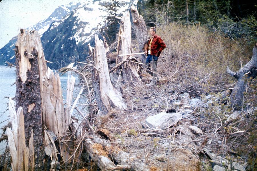
A forlorn couple stands on a concrete dock viewing the remains of the Kodiak waterfront on March 29, 1964. #AP Photo![]() Read moreTrees up to 24 inches in diameter and 100 feet above sea level were broken and splintered by the surge wave generated by an underwater landslide in Port Valdez on Prince William Sound. #U.S. Geological Survey
Read moreTrees up to 24 inches in diameter and 100 feet above sea level were broken and splintered by the surge wave generated by an underwater landslide in Port Valdez on Prince William Sound. #U.S. Geological Survey![]() Read moreThis truck was bent around a tree by the surge waves generated by the underwater landslides along the Seward waterfront. The truck was about 32 feet above water level at the time of the earthquake. #U.S. Geological Survey
Read moreThis truck was bent around a tree by the surge waves generated by the underwater landslides along the Seward waterfront. The truck was about 32 feet above water level at the time of the earthquake. #U.S. Geological Survey
Most Recent
Oli Scarff / AFP / Getty - In Focus
- Jun 29, 2018
- 35 Photos
Photos of the Week: Wild Horses, Scarlet Sails, Sun God
Reiko Takahashi / National Geographic Travel Photographer of the Year Contest - In Focus
- Jun 28, 2018
- 10 Photos
Winners of the 2018 National Geographic Travel Photographer of the Year Contest
Ahn Young-joon / AP - In Focus
- Jun 27, 2018
- 40 Photos
Photos: Fans of the 2018 World Cup
Clodagh Kilcoyne / Reuters - In Focus
- Jun 26, 2018
- 32 Photos
Rohingya Refugees Earning a Meager Wage in the Fishing Industry
Most Popular on The Atlantic
- The Trade Deficit Is China’s Problem
- The 9.9 Percent Is the New American Aristocracy
- What’s Going on With Novak Djokovic?
- Winners of the 2018 National Geographic Travel Photographer of the Year Contest
- Family Separation Protests Shift the Narrative
- The Dangers of Distracted Parenting
- It’s Time for Trump Voters to Face the Bitter Truth
- John Steinbeck on Falling in Love: A 1958 Letter
- I Delivered Packages for Amazon and It Was a Nightmare
- Terry Crews and the Discomfort of Masculine Anxiety












No comments:
Post a Comment
Note: Only a member of this blog may post a comment.